BWCA, Boundary Waters Canoe Area Web site

BWCA, Boundary Waters Canoe Area, Canoe Trips

BWCA, Boundary Waters History, Rules, Regulations, Permits

BWCA, Plan Your Boundary Waters Trip, Maps, Permits

BWCA, Boundary Waters Canoe Trip Ethics, Leave No Trace, Minimum Impact Camping

BWCA, Resorts, Lodges, Campgrounds, Cabins, Rentals, Lakeshore Rentals

BWCA, Canoe Outfitters for the Boundary Waters and Quetico Park

BWCA, Boundary Waters Discussion Forum, Bulliten Board, List Server


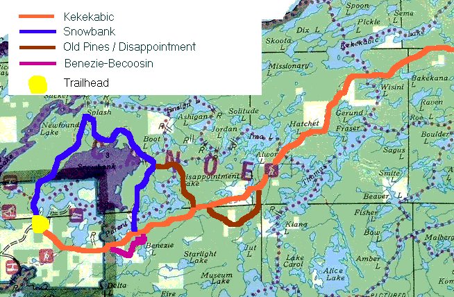
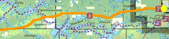
CanoeCountry.com
Boundary Waters Canoe Area Web site
Map of the Kek Trail


(Western Area)

kekmap.jpg (115216 bytes)

(Eastern Area)

eastkek.jpg (38115 bytes)

Additional InformationKekekabic Trail Guidebook and trail maps

These maps are not to be used for navigation.  They do, however, give
an idea of the trail's location and proximity to area lakes.  Trail is
shown as a solid line.  Dotted lines are canoe routes.

Click here to see the entire map of this region (East of Ely) and
West of Gunflint Trail


BWCA Hiking Permi Border Route trail Disappointment trail
Herriman trail Kekekabic trail Powwow trail
Snowbank trail BWCA Maps Angleworm trail


Boundary Waters Canoe Area Web site
Over 24 million visitors have used this service in the past 11 years!
Vacation Property | BWCA Bulletin Boards | Canoe Country Jobs | Canoe Country Blogs

Home | Outfitters | Plan Your Trip | Where to Stay | Guided Trips | Discussion | Buy Gear | History | Ethics | EDUcational

About | Winter Fun | Permits | Hiking | Books | Jobs | Realty | Maps | Weather | Image Gallery | Links 


Request Advertising Info
Don't have a Web site? 
We can create one for you
click here

Privacy Policy | Media and Public Relations

Published from the edge of the Boundary Waters
Canoe Area by Chad Jones

Updated August 6, 2008

All Original Content and Coding
Copyright © 1996-2008 BWCA Web site/CanoeCountry.com
All Rights Reserved Disclaimer and Copyright Notices